If you like these maps, consider following me via e-mail. I expect to add new maps to this page as I write more novels, and when I do, I’ll notify my Loyal Readers first via my e-mail newsletter.
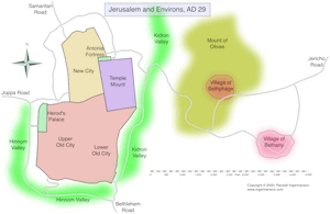
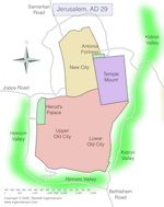
This is one of a pair of maps from the book Son of Mary. This one shows Jerusalem in the early part of the first century. Probably in the early 40s, the northern wall was extended to enclose more territory by King Herod Agrippa I, and that wall closely follows the current wall of the Old City of Jerusalem in modern Israel. The modern-day Church of the Holy Sepulchre, which is inside the current Old City, was just west of the area marked New City on the map. This is the traditional site of the crucifixion of Jesus, and many scholars believe that it may be very close to the actual site. But a fair number of scholars disagree.